![[Map of segment 23]](../imagestc_e/tc_carteseg23_e.gif)
From Gaspé to:
 Sainte-Anne-des-Monts (segment 22)
Segment 23: From Gaspé to Percé
Gaspé
- Cathedral
The only wooden cathedral in North America![[Picture of the Musée de la Gaspésie]](../../../imagesite/photos/tc_seg23img01.gif)
- Musée de la Gaspésie
Museum housing exhibits on the history of the peninsula. In the park nearby is the Jacques Cartier Monument National Historic Site, commemorating the cross erected by the French explorer in 1534.
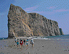
Parc de conservation de l'Île-Bonaventure-et-du-Rocher-Percé
![[Picture of the Île Bonaventure]](../../../imagesite/photos/tc_seg23img03.gif) Park located on an uninhabited island, flanked by steep cliffs, and home to
exceptional vegetation and wildlife. Bird sanctuary with 50 000 gannets. Nature
observation. Hiking trails. The park also includes Rocher Percé, the
famous limestone rock formation over 400 m (1,312 ft) long and 88 m (289 ft)
high, pierced by erosion caused by the waves.
Park located on an uninhabited island, flanked by steep cliffs, and home to
exceptional vegetation and wildlife. Bird sanctuary with 50 000 gannets. Nature
observation. Hiking trails. The park also includes Rocher Percé, the
famous limestone rock formation over 400 m (1,312 ft) long and 88 m (289 ft)
high, pierced by erosion caused by the waves.
Percé
 Carleton (segment 24)
![[Back to the welcoming page
of Quebec]](../../../imagesite/icones/bienvenue_ic.gif)
![[Back to Tourism and culture]](../../../imagesite/icones/tc_intro_ic.gif)
![[Back to the
itineraries]](../../../imagesite/icones/tc_circuits_ic.gif)
![[Regional Weather]](../../../imagesite/icones/tc_meteo_ic.gif)
![[Index]](../../../imagesite/icones/tc_index_ic.gif)
![[Your comments]](../../../imagesite/icones/comments_ic.gif)